
Golden Hill

Horfield & District Allotment Association (H&DAA) manages allotment sites in the Bishopston and Horfield districts of Bristol. The Association was founded in 1917 and one of its earliest sites was a set of fields in a site called Golden Hill which is still in use as allotments today, 100 years later.
Figure 1 shows a recent aerial view of the current Golden Hill allotment site, with the site boundary outlined in green. There are 4 fields on the site: St. Agnes, Davies, Baptist and Long’s. An access lane separates Long’s from the other 3 fields. Horfield Prison is on the right corner of the photo.
- Where exactly is Golden Hill?
- Who owned and occupied Golden Hill in the past?
- When were allotments established on Golden Hill?
- What is H&DAA’s history on Golden Hill?
- How have the Golden Hill allotments developed over time?
Where is Golden Hill?
Golden Hill is one of the highest points within the Bristol City environs and is located across the Horfield, Bishopston and Henleaze districts. It is said that the name Golden Hill derives from the fact that it was a pre-Christian beacon hill. It has also been suggested it has an ancient pagan origin and the remains of a tumulus nearby could well support this theory.
Golden Hill is an area that is not precisely defined. In the 18th Century Manor Court presentments, there was an Upper Golden Hill Lane which looped between what is now Brookland Road and Lansdown Terrace. In the 1843 Tithe survey map, two fields were called Golden Hill. These lie north west of what is now Kellaway Avenue, between Phoenix Grove and Brookland Road. They also include a small row of late 19th Century cottages called Golden Hill which still exist today.
The 1844-1888 OS 1st Edition Map in Figure 2 shows the Golden Hill area centred around Quabs (or Quabb) Farm, at the southern corner of Horfield Common where Highfield Grove is now. The row of cottages to the west is the start of what became Kellaway Avenue.

In current street maps, Golden Hill is shown at the Sports Ground behind the Tesco Supermarket on Kellaway Avenue (i.e. to the north of Kellaway Avenue).
Who owned and occupied Golden Hill?
Golden Hill formed part of a much larger estates land under the Manor of Horfield. The ancient manorial system of land tenure had existed for centuries. In 1140 Lord Berkeley, whose estates included the Manor of Horfield, founded St. Augustine’s Abbey and gave the Manor to the Abbey in whose possession it remained for the next 400 years. Horfield Manor court presided over the system of fields which had been formed during the enclosures in the late 15th century. When monastic holdings were confiscated by Henry VIII during the Reformation in the 1530s, he gave the Horfield Manor estate to the newly formed Bishopric of Bristol not the Church of England – but the Bishop himself who then leased it to what was known as a Lord Farmer.
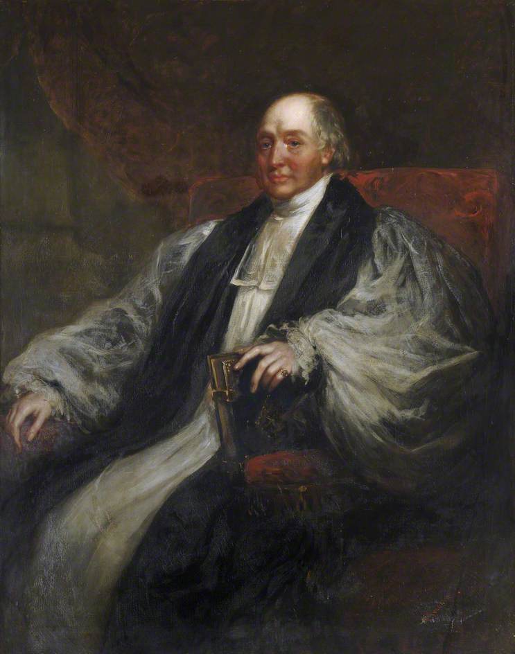
In 1836 James Henry Monk was appointed as Bishop of Bristol and Gloucester. At this time the Lord Farmer lessee was Dr John Shadwell, who had tenure for life, the land having been in his family since the Reformation. The small farms within this area were held by him under a system of customary law called “copyhold”. There were 1000 acres of copyhold land in Horfield and Filton. When Shadwell died in 1849, Bishop Monk set about converting the copyhold land into freehold. Bishop Monk sold part of the estate and leased the remainder to his secretary and other trustees of the newly formed Bishop Monk’s Horfield Trust which was formed in 1852. The objective of the Trust was to provide money for clergy in poorly-endowed parishes ad contribute to the spiritual well-being of the whole diocese. After 700 years the Manor of Horfield was finally broken up, this time never to be re-established.
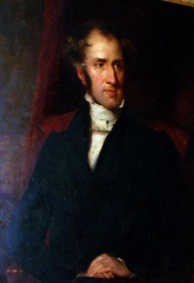
Another clergyman who had an influence on the land in Horfield was Rev Henry Richards. He was the Perpetual Curate of Horfield (1828-1863) whose parish covered Horfield and a large part of the area we now know as Bishopston. In fact it was Rev Richards who organised the Parish of Bishopston in 1862. Rev Richards was a wealthy man and had bought some of the copyhold farms in Horfield in the 1830s. Thus he was the owner of the land and leased it out to tenant farmers.
Land owned by Rev Henry Richards appeared in the 1843 Tithe Survey in Golden Hill (Figure 3). Fields called Lower Gaskins, Hither Gaskins and Further Gaskins which are those numbered 57, 58 & 59 on the 1843 Map. (This is the land we now know as St Agnes Field, Davies Field and Baptist Field – the current allotment site is marked out in green). These fields were farmed by tenant farmers: in this case, a Timothy Smith was listed as occupying these and other fields. Timothy Smith had been employed as gamekeeper by John Shadwell, the Lord of the Manor, but by 1841 he may have been working the land in his own capacity. The term Gaskins is thought to mean “grass enclosure” from the middle English.

Another field called Middle Allhays (number 65 on the 1843 Tithe Survey Map) was occupied by a Peregrine Rosling and was leased from Henry Eugene Shadwell who was the son of Dr John Shadwell, the Lord of the Manor. (This is the land we now know as Long’s Field). Peregrine Rosling had come to live in Horfield from Corby, Lincolnshire, and must have attended Horfield Parish Church as his name was on a petition to rebuild Horfield Parish Church in 1836. At that time there were several branches of the Rosling family shown as living on The Common, including his brother Reuben Rosling who ran Berry Lane Farm.
In Figure 3, a pathway called Gaston Lane can be seen running alongside plots 58 & 59. This lane still exists and is known locally as Donkey Lane or Dead Man’s Lane. It is an ancient lane that probably goes back over 500 years. The hedgerows that border it are certainly of this age. It was never a through road, but was an access lane or “occupation road” leading from Horfield Common to outlying fields. It is still in use today for access to the allotments and as a pedestrian cut-through between King’s Drive/Bishop Road and Longmead Avenue.

In 1886, land including Lower Gaskins, Hither Gaskins, Further Gaskins (Plots 57, 58 & 59 on the sale deeds map in Figure 4) was sold by the Trustees of the Rev Henry Richards’ estate to John Mitchell Eugene Taylor Shadwell who was the grandson of Dr John Shadwell the Lord of the Manor. The plan from the deeds of sale shows that the land north of these plots was already in the hands of the Shadwell Estate. This must have included the Middle Allhays land previously owned by Henry Eugene Shadwell who died in 1858. It is assumed that all this newly purchased land was then brought into the Shadwell Estate. Two of the plots were described as pasture and the other one as partly arable land.
When were the first allotments laid out in Golden Hill?

When Samuel Loxton completed his drawing of Horfield Prison (Figure 5), he must have been positioned in the very spot referred to as “Allotment Gardens” in the OS map (Figure 6). Here you can see the Prison, which was built in 1883, and in the foreground there are workers on the Allotment Gardens. They appear to be working on the land planting or sowing vegetables.

The 1894-1903 OS Map 2nd Edition (Figure 6) shows a large L-shaped piece of land, labelled as “Allotment Gardens”, which comprises the current Davies Field and half of the Bishop Road School Field. No other land in the nearby district is labelled as being allotments. It is not known what form these allotments took and who managed them.
The first allotments as we know them in the Golden Hill area were laid out in 1909 and they were managed by the Bristol Corporation’s Smallholdings & Allotments Committee. These were not on the Golden Hill site that H&DAA now run, but were located just south of Quabs Farm, across the current Maple Road and Beloe Road. They were leased from the Bishop Monk’s Horfield Trust. However, in March 1909, just before the Corporation was due to take them over, Mr Cox, the previous tenant, declared that he had sublet the plot to another man who in turn had sublet it to the Schoolmaster’s Cricket Club for the coming cricket season! The Corporation were not fazed by this and increased their compensation to Mr Cox and took over the site in April, 1909.
This site continued to be used as allotments, run by Bristol Corporation, until the 1920s when Maple Road was extended to meet Longmead Avenue and houses were built on it and Beloe Road. There is a remnant of these allotments still in existence today behind the Maple Road and Beloe Road houses.
When did H&DAA first use the Golden Hill site?
During WWI there were many attempts by Bristol Corporation to obtain further land in the Horfield and Bishopston district to meet the growing demand for allotment plots. In October 1917 the Corporation’s Smallholdings & Allotments Committee conducted a survey of land suitable for use as allotments. Among the sites inspected were the following:
Owner: Shadwell Trustees
Occupier R Davies, Brynland Ave., Horfield, Wheelwright, Undertaker and Cattle Dealer
Used for hay and occasionally cattle
Plot No. 196 (with 191) late Horfield Baptist CC Area: 5 acres, 0 rod, 5 perch
Owner: Shadwell Trustees
Occupier W. Long greengrocer, Gloucester Road
Used for grazing cattle
As can be seen from the map in Figure 6 above, Plot 212 is what we now call St Agnes Field and Plot 196 is what we call Baptist Field.
In September 1918, H&DAA started leasing St Agnes Field (Plot 212) and Long’s Field (Plot 199) from Bristol Corporation who in turn leased it from the Shadwell Trust. These were the first sites on Golden Hill managed by H&DAA.
How did the Golden Hill allotment site develop?
In November 1920, huge tracts of land owned by the Shadwell Trust estate in Bishopston, Horfield and Filton were put up for sale. The map in Figure 7 below shows some of the lots, with handwritten names indicating the names of fields.

In June 1921, Bristol Corporation completed the purchase of Lots 8 and 9 (but not Lot 5). Thus St. Agnes, Long’s and Davies Field were acquired. These were already leased out to H&DAA for allotments use. Davies Field, which was also bought by the Corporation as part of Lot 9, was in use by Mr R. Davies, the Funeral Director, for grazing his horses, and possibly also cattle. He was given notice to quit this field by the Corporation and, some time in 1921, H&DAA were given a lease for this land. Thus the Golden Hill site now comprised:
St. Agnes Field
Longs Field
Davies Field (aka Davis Field)
The total acreage was approximately 12½ acres and there were around 250 plots.
A further extension of the allotments on the Golden Hill site took place in February 1927. Bristol Corporation agreed to swap a parcel of land adjacent to Long’s Field of just over an acre (coloured brown on the map in Figure 8) for 2¾ acres of land which is Baptist Field (coloured green). In addition to this Mr Jennings was paid £360. The land that was swapped would eventually be used to build houses for the newly extended Longmead Avenue.

Mr Jennings had previously purchased much of the land either side of Longmead Avenue. He had also bought the remains of Quabb Farm which had been a working farm run by Mr. Brimble until 1925, and it is thought that H&DAA had leased the field when it was owned by Mr. Brimble.

The aerial photo (Figure 9) showing Horfield Prison and Golden Hill was taken in the early 1930s and show that the Golden Hill site used for cultivation was larger than the outline in the map in Figure 8 above. This is because the Bishop Road School field was turned into vegetable plots. Also the Longmead Avenue development had not been completed and there were still allotments there. It is not known for sure whether these additional areas were under H&DAA management.
This was also a time when there was pressure on land use in the Bishopston and Horfield district. In 1938, Bristol’s Education Committee was in discussion with Bristol’s City Valuer to try to acquire all 14 acres of the Golden Hill allotment site for education purposes. The City Valuer reminded the Committee that land was bought to prevent its use for building and that the Golden Hill allotments were now the only remaining allotments in the district. Thus the attempt to remove the allotments failed.

By the time WWII had ended, the more familiar shape of the Golden Hill allotment site was emerging. As this 1946 aerial photo shows (Figure 10), Longmead Avenue was now complete, and the Long’s and Baptist Fields are defined by their current boundaries. The only variation from the current Golden Hill allotment site is that the southern edge has allotments up to the houses on Bishop Road, taking in the Bishop Road School Playing field.
The final shaping of the H&DAA Golden Hill Allotment site came in 1967, when it was agreed that there be an exchange of land between the Education Department and the allotment site. In the map in Figure 8 above, the land coloured pink was exchanged for that coloured blue. This increased the size of St, Agnes Field, while reducing the size of Davies Field, but the overall shape now matched the current Golden Hill site as shown in the 2012 Aerial photo.
H&DAA Golden Hill progress
Although there were no further changes to the size and shape of the H&DAA allotments site on Golden Hill after 1967, there were alterations in other ways.
In 1954, water troughs and mains water had been established throughout all the fields on the Golden Hill site, with a grant being obtained to pay for them.
In the 1970’s the Horfield Prison authorities tried to obtain land on St. Agnes Field near the prison for car parking facilities. This request was repelled and the land kept for allotment use.
To read more about the Golden Hill site from the 1980s onward, follow the links below:
Development of Golden Hill in 1980’s, 1990’s, 2000’s
Horfield Organic Community Orchard
References
OS Map Images from Know Your Place Bristol
Bristol Archives 40297/D/5 Deeds & Papers Shadwell Estate
Bristol Archives: M/BCC/ALL/1/1 BCC Allotment Committee Minutes 1908-15
Bristol Archives: 43310/M/2 BCC Smallholding & Allotments Committee Minutes 1913-1919
Bristol Archives:: 43310/T/1 Terrier BCC Smallholding & Allotments Committee Permanent Allotments A-L
Bristol Archives: 40297/PM/1 Shadwell Estate Sale of Lands in Horfield and Bishopston
Bristol Archives: 40297/D/5 Deeds and papers of Shadwell Estate 1886
Bristol Archives: PicBox/1/AVU/96 Aerial view of Horfield Prison 1930s
Bristol Library: Loxton S1101 Drawing of Horfield Prison from the Allotment Gardens
Bristol Archives: 45420 Personal Papers for William Pain
Bristol Archives: 40620/1/8 Horfield & District Allotment Association Archive
Bristol Archives: 40620/1/9 Horfield & District Allotment Association Archive
Bishopston The Early Years – Denis Wright & John Hyde ISBN-13: 978-0-9555826-4-6
The Horfield Tithe Survey 1841 – Denis Wright & John Hyde ISBN978-0-9555826-0-8
Bishopston, Hoirfield and Ashley Down – Local History Society ISBN 0-7524-1057-1
Image of Henry Richards – courtesy of the parish of Horfield Bristol
Image of Bishop Monk